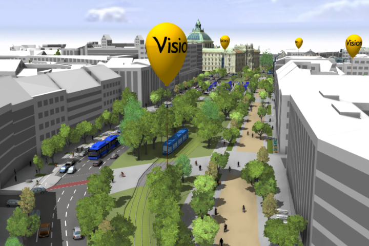
3D Visualization and standardized Representation of the Lane-Model

Result of the project Digital Twin Munich as part of the funding guideline "Digitalization of Municipal Transport Systems" by the Federal Ministry of Transport and Digital Infrastructure. 

The picture shows a street scene based on the 3D model, which includes the results of the traffic simulation in the form of 3D models of road users for the Sonnenstrasse.

The standardized 3D modelling of roads and the street space enables its use for numerous applications and visualizations.

As part of the Digital Twin Munich project, a lane-model is developed and visualized with the aim of providing a comprehensive and precise representation of the street space with lane-level accuracy and including traffic logic. This model is based on extensive survey data and existing geospatial information. The lane-model includes individual driving lanes, bicycle paths, nearby vegetation, road markings, and areas used by pedestrians. This data is converted into the international standard CityGML, which is used to represent semantic 3D city and street space models. The lane-model can therefore be used for environmental simulations and analyses, as well as interactive 3D visualizations. The associated modelling guide, Road2CityGML3, is based on insights gained from the Digital Twin Munich project.

Contribution to the digitization of municipal transport systems

The standardized representation of the street space, including geometric, semantic, topological, and visual aspects, contributes to the digitization of the municipal transportation system. Simulation, analysis, and visualization tools require detailed, and ideally standardized, input data to perform their tasks. This is ensured through the use of international standards.

Contribution to air pollution control / clean air in the City of Munich

Digital 3D models of the street space enable numerous environmental simulations and analyses. Customized mobility concepts, such as replacing driving lanes with bicycle paths, have an impact on traffic flow as well as air quality. Digital simulations and visualizations of various scenarios allow for the assessment of the respective effects of measures before their actual implementation, thereby helping to make informed decisions for the future of the city.

Perspective of the action

The ongoing development of the lane-model seeks to offer detailed information about Munich's street space throughout the entire city, ensuring lane-level accuracy. This information will be made available through an interactive 3D Cesium visualization. Additionally, dynamic sensor data and real-time information, such as traffic congestion, will be integrated into these visualizations.

Videos

Galerie

Related Links

Other Results

3D Ansicht der Sonnenstraße

Public Participation with the 3D City Model

Enhancing citizen participation by visualizing future scenarios using the 3D city model of the Digital Twin Munich.

Representation of the procedure model for deriving indicators for evaluating the service quality of cycle paths using a standardized evaluation system from a semantic 3D city model and an excerpt of the result for the

Indicator-based Analysis based on the 3D City Model

Indicators derived from the Digital Twin Munich allow the evaluation and comparison of “what-if scenarios”.

Sendlinger Tor Platz: View of combined 3D city model.

Semanticized 3D mesh model

Derivation of a semantic 3D city model from the photorealistic mesh model.

A surveying vehicle from iNovitas equipped with camera setup. On the rear window, it reads 'Please keep distance Mobile Mapping', while on the side of the vehicle, 'infra3D Services' is displayed along with a sticker stating 'on behalf of the City of Munich, Department of Communal Services GeodataService'.

Mobile Mapping and Feature Extraction

The Digital Twin Munich uses panoramic images and inventories to support the city administration.

The construction sites map can be viewed on the Geoportal. With the help of icons, the map provides an overview of current and planned construction sites and no-stopping zones in Munich that will cause restrictions on driving, walking and parking over the next two to six weeks.

Interactive construction sites map in the Munich GeoPortal

See all construction sites and temporary traffic disruptions online at one glance.

lane-level model of the road network between central station, the Lenbachplatz and the Sophienstraße.

City-wide lane model: lane-exact representation of the road space

The lane model contains the entire road system of Munich in a simulation-enabled data structure.

A person is standing on the street by a manhole cover. They are holding a long pole with a GNSS receiver for measuring control points.

Development of a city-wide network for control points

In order to integrate road traffic into the digital twin, high-precision measurement control points are required.

The Munich Olympic Stadium in Minecraft.

The Digital Twin Munich in Minecraft

Including the Digital Twin Munich as part of the Minecraft game provides a great opportunity to involve young people in participation and planning processes.

Exemplary modeling of traffic-related air pollution through nitrogen oxides (NOX) by the Technical University of Munich based on data of the Munich Digital Twin. The modeled concentration of nitrogen oxide emitted by traffic per cubic meter of air is shown.

Modeling of Traffic-Related Air Pollution

The combination of multiple data sources enables the modeling of traffic-related air pollution.

Bird's-eye view of the high-resolution 3D model of the Oktoberfest based on drone-based data acquisition integrated into the city-wide 3D model of the Digital Twin Munich.

Drone flights to survey and update the Digital Twin Munich

Drone-based data collection is suitable for capturing temporary and shot term or structural changes within the city and updating the city-wide data of the Digital Twin Munich.

Mapping Bike

Mapping Bike – area-specific update of the streetscape and supporting for drone flights

The concept of the mapping bike was developed in collaboration with the Technical University of Munich (TUM) to record changes in road construction and to complement drone-based data collection.

On display is a holistic 2D data integration for optimizing urban planning processes for transport infrastructure in Plexmap.

An innovative geodata exchange platform

The geodata exchange platform is the agile sub-project platform of the Digital Twin Munich and uses Plexmap for holistic 2D and 3D data integration to optimize urban planning processes.

Shared use of the AR application for interactive planning visualization in the office.

With the help of augmented reality (AR), future construction projects are projected into today's reality

Experience today what will be built tomorrow. With AR, future construction projects can easily and directly on site be superimposed and displayed together in today’s realit

Dashboard overview with selection options for various sensor values.

Geodashboards within the Digital Twin Munich

Geodashboards support informed decision making by visualizing complex geodata from the Digital Twin Munich.

Teamwork Illustration

Co-creation for the Digital Twin Munich

The Digital Twin Munich project is an excellent illustration of how visionary ideas and interdisciplinary collaboration positively impact urban development.

Visualization from the simulation environment

Sumonity: Bridging SUMO and Unity for Enhanced Traffic Simulation Experiences

An interface combining SUMO's traffic modeling with the Game Engine Unity for realistic traffic simulations.

The house of the future: Digital Twin Munich (DT-M)

The house of the future: Digital Twin Munich (DT-M)

The conceptual design of the DT-M house shows which professional skills and technical components are required to realize the DT-M.

Contact